
Heading away from Gullfoss took us back past the Haukadalur Valley and along the way in which we had come from Reykjavik before we turned right for Þingvellir National Park.

We didn't know what to expect at Þingvellir, except that we knew that it was home to one of the oldest parliaments in the world as well as a site where the North American and Eurasian continental plates (Mid-Atlantic Ridge) can be seen.
We got a whole lot more.
Þingvellir, pronounced Thingvellir, has been a UNESCO Heritage site since 1930. 1,000 years before, in 930AD, the Alþing (pronounced Althing which is the Icelandic open-air assembly) was established, and continued to meet for 2 weeks a year at Þingvellir until 1798. The Assembly set laws (including the introduction of Christianity to Iceland in 1000AD) and settled disputes, and there is a dark past in some site locations where people were killed for their crimes. Mothers of illegitimate children were drowned at Drekkingarhylur; convicts were beheaded at Þorleifshólmi; the obvious was performed at Gallows Rock.

 Drekkingarhylur
 There's a lot more to learn about how the Alþing worked and there are excellent websites which do it a whole lot better than I could in one blog post:
Official Þingvellir website
Discover South Iceland website
Wikipedia
Parking the car, we woke up 2 grumpy boys who had unfortunately fallen asleep only 10 mins prior to our arrival at the site. Their vociferous protestations were ignored, and they sulkily followed us for 15 mins before waking up again to explore a few cave-like holes in the rocks.
 We don't want to walk no more
We headed over a small bridge and up the pathway which leads between the 2 continental plates. This is the main Almannagjá (Everyman's Gorge) fault. The plates move apart by a further 2.5cm per year, so Iceland continues to increase in land size. As a consequence, earthquakes are not uncommon in this area.
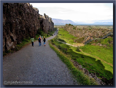 The higher North American plate is on the left and the Eurasian plate on the right
Almannagjá is a collective term for the gorges that extend almost continuously from Lake Þingvallavatn north to Mt. Ármannsfell. Over the past 10,000 years the area has subsided by about 40 metres and the tectonic plates have separated by 70 metres.
Approximately halfway up the path is a wooden walkway off to the left which leads to an area called Lögberg (Law Rock). Although the exact location is disputed and unlikely to ever be confirmed, Lögberg is where the assembly was officially opened and closed each year. It was also the site for speeches on important issues, legal actions, and news announcements.
 The Icelandic flag marks the area known as Lögberg
Official Þingvellir website
Discover South Iceland website
Wikipedia
Parking the car, we woke up 2 grumpy boys who had unfortunately fallen asleep only 10 mins prior to our arrival at the site. Their vociferous protestations were ignored, and they sulkily followed us for 15 mins before waking up again to explore a few cave-like holes in the rocks.
 We don't want to walk no more
We headed over a small bridge and up the pathway which leads between the 2 continental plates. This is the main Almannagjá (Everyman's Gorge) fault. The plates move apart by a further 2.5cm per year, so Iceland continues to increase in land size. As a consequence, earthquakes are not uncommon in this area.
 The higher North American plate is on the left and the Eurasian plate on the right
 Almannagjá is a collective term for the gorges that extend almost continuously from Lake Þingvallavatn north to Mt. Ármannsfell. Over the past 10,000 years the area has subsided by about 40 metres and the tectonic plates have separated by 70 metres.
Approximately halfway up the path is a wooden walkway off to the left which leads to an area called Lögberg (Law Rock). Although the exact location is disputed and unlikely to ever be confirmed, Lögberg is where the assembly was officially opened and closed each year. It was also the site for speeches on important issues, legal actions, and news announcements.
 The Icelandic flag marks the area known as Lögberg
For 2 weeks each year, the Lögrétta (Law Council) and the courts went about their tasks in an area which was defined by boundaries formed by Kastalar, two lava hills on the northernmost part of Neðri-Vellir; Lake Þingvallavatn in the south; the higher wall (North American plate) of the Almannagjá fault in the west; and Flosagjá in the east.
 The ruins of booths where the “Þingmen” (Thingmen) and other assembly visitors stayed can be seen in several areas.
We continued to the top of the path to Hakið where an Information Centre has been built. The Centre hosts a 40 minute multimedia display (on touch screen monitors) which describes the history and natural environment of Þingvellir and its surroundings. The boys perked up at the sight of the touch screens (ooh - technology!) and when they found that, out of the 5 language choices, one of them was German, they were hooked!
I left J and the kids in the building and walked out onto the lookout (which is built over the fault line) to gaze at the view from a high point. On my left I could see the path that we had come along, dwarfed by the high North American plate, with Mt. Ármannsfell in the background.

On my right, the fault continued towards Lake Þingvallavatn. Apparently, diving the fault line in the lake is an amazing sight, and although we love to dive, we weren't tempted on this trip due to a number of factors: cold, kids, cold, time, cold, cost, cold, cold water, cold anything - any excuse would do to get us out of diving in cold water!

At 100m above sea level, this is the largest lake in Iceland covering 83sq km (32sq miles) and over 100m (328ft) deep. This means that in some places, the lake's bottom is below sea level. The only outflow from the lake is the Sog River which is a famous salmon river. The lake's catchment area is largely underground and the water has a constant annual temperature of 3-4°C - more on this later when we get to Flosagjá.

Directly in front of me was the main area in which a lot of the business of the Lögrétta was achieved during the 2 weeks of the Alþing each year. In the foreground is Hotel Valhöl, which opened on 20 August 1898 and is open all year round. Originally located by Kastalar in the northernmost part of the old parliamentary site, it was moved to its present position in 1929.

Across the Öxará (Axe) River, the little building on the left is the church Þingvallakirkja and behind it is the circular National Cemetery which was established in 1940. 2 famous Icelandic poets - Einar Benediktsson (1864-1940) and Jónas Hallgrímsson (1807-45) - are buried there.
The larger white building is the manor house which was designed by State Architect Guðjón Samúelsson for the Alþingi millennium celebrations in 1930. It was built on the same site as all the Þingvellir farm buildings have stood over the centuries. The Manor House is now the official summer residence of the Icelandic Prime Minister and also houses the offices for the National Park's management, as well as facilities for the church clergymen and guests. It's a busy building!
After wearing out the interactive media show, J and the kids joined me outside and we walked down a path which led around the hotel, over a bridge and towards the church and Manor House.
 The Öxará River with Lögberg in the distant left and the Manor House on the right bank
The surrounding vegetation and waterways are havens for birds and animals such as mink and arctic fox. It's a beautiful sight.

As we walked along the east side of the river, we could see where we had been on the western side: past Lögberg and in between the 2 continental plates.

The tiny church was so full of people that we beat a hasty retreat, skirting around the National Cemetery and onto a path that would ultimately take us back to the carpark.
We arrived at Flosagjá (Flosi’s Gorge) which was the Alþing's eastern boundary. The gorge contains groundwater which feeds into Lake Þingvallavatn - one of the few areas in which you can see the groundwater flowing into the lake as 90% of it flows into the lake underground. The catchment area of Þingvallavatn is about 1300 square kilometres in size and it takes 20-30 years for water to run south into Þingvallavatn from the glacier Langjökull which we saw on the way to Gullfoss. The rain that falls on the lava takes 2-4 months to enter the lake as it's filtered through the porous rocks.

As a result of all that lava filtering, the water in Flosagjá is some of the purest and clearest that we have ever seen - equal to the visibility in New Zealand's Te Waikoropupu Springs where the water is filtered through limestone.

The crystal-clear water never freezes (I would guess because there are not enough impurities to help it to freeze), and the bottom of the deep gorge can be seen at all times of the year.

We could see the silver coins on the bottom. The temperature of the water in the gorge remains constant all year at 2.5–3.5°C. This didn't deter the older boy from wanting to go in for a swim. I think that all the coins were too tempting to resist, but little did he know that we weren't going to let him take any! So, we let him go ahead. After 15 mins of fluffing around removing his clothes, he finally sat on the edge of the gorge.

This is how far he got. One big toe in the freezing water and he was up and dressed again in a flash!

Þingvellir is an amazing place to visit, and without kids I could have spent the whole day here taking photos and walking around the various sites.
By now it was past 7pm (hard to tell when the sun doesn't set) and we were weary after a long day on the road. We drove back to Reykjavik to cook dinner and put the kids to bed, knowing that another full day was ahead of us in the morning.
Next Chapter: Down south in the rain
By now it was past 7pm (hard to tell when the sun doesn't set) and we were weary after a long day on the road. We drove back to Reykjavik to cook dinner and put the kids to bed, knowing that another full day was ahead of us in the morning.
Next Chapter: Down south in the rain
4 comments:
After a lifetime of seeing muddied, polluted waters, Flosagjá is like a shock to the system!!! But what a great shock!!! Words can't describe my wonder right now, so I'm just going to say I'm glad you were there, and even more glad you put these pictures up!!!
Thanks! It does make a change from seeing less than pure water that's for sure.
To think that most rivers and streams in the world were once like this before pollution invaded is very sad.
Your Elf Speech has come on, hasn't it?
Heh - it was like reading Lord of the Rings all over again and getting distracted from the storyline by trying to correctly pronounce the words!
Post a Comment